 Geraneia topoguide
1.7
Geraneia topoguide
1.7
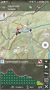
The application offers detailed offline maps and an extensive introduction on geography, geology, the nature and the rich ancient history of Geraneia Mts. Special attention is given to the rich flora of the area, with dozen of are plant species described and plotted on the map.
Geraneia topoguide offers also a useful list of POIs with a comprehensive search engine.
The trails list includes 14 easy and moderate hiking trails and long mountain traverses, of a total length of 118 km, as well as 2 MTB routes and 3 geological routes.
In the field, the app identifies the nearest adventure, guides you to it and then along it by displaying messages and warnings on every junction or other important location. On each Point of Interest, photos and texts are displayed on the map. If the hiker gets off-trail, the app indicates the shorter way to get back safely.
The cartographic company AnaDigit, creator of the application, has issued previously detailed hiking maps at a scale of 1: 25,000 for Geraneia Mts., as well as hundreds other hiking maps for Greece (eg. maps of Mt. Olympus, Crete, Zagori, Sifnos, Naxos and other Aegean islands). To build the application and ensuring data accuracy, all paths of Geraneia Mts. have been revised during 2018.
Fotogalerie


-
Verze programu
1.7
-
Poslední aktualizace od vývojáře
31. 1. 2020
-
Počet stažení za měsíc
0 ×
-
Velikost
14 MB
-
Potřeba instalace:
Ne
-
Web autora
-
Podporované jazyky
- Angličtina ,
- Řečtina
Cena: 149,99 Kč
Sdílet
Podobné programy


TIP: Stahují se vám programy pomalu? Změřte si rychlost svého internetového připojení.