 Locus GIS - land survey, data collection, SHP edit
1.3.0
Locus GIS - land survey, data collection, SHP edit
1.3.0
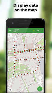
Professional GIS application for working with geodata in the field. It enables both data collection and viewing. All its features are available over a wide selection of the world's best online and offline maps.
Fieldwork
• collecting and updating field data
• saving points with current or arbitrary position
• creating lines and polygons by motion recording
• setting related data
• photos, video / audio or drawings as attachments
• guidance to points
Import / Export
• importing and editing ESRI SHP files
• exporting data to ESRI SHP or CSV files
• exporting whole projects to QGIS
Maps
• wide range of online maps
• support of WMS map sources
• support of offline maps in MBTiles, SQLite, MapsForge, TAR, GEMF, RMAP formats and custom OpenStreetMap data or map themes
Other useful features
• measuring distances and areas
• searching and filtering of data in attribute table
• style editing and text labels
• organizing data into layers and projects
Fotogalerie


-
Verze programu
1.3.0
-
Poslední aktualizace od vývojáře
6. 2. 2020
-
Počet stažení za měsíc
1 ×
-
Velikost
16 MB
-
Potřeba instalace:
Ne
-
Web autora
-
Podporované jazyky
- Angličtina
Zdarma
Sdílet
Podobné programy


TIP: Stahují se vám programy pomalu? Změřte si rychlost svého internetového připojení.