 survey : clinometer, compass and range finder
1.6
survey : clinometer, compass and range finder
1.6
Used mainly for surveying and have been adapted for specialized purposes in fields like meteorology and rocket launch technology.
That combines viewfinder, clinometer, compass, GPS and map.
Triangulation consists of making such direction plots of the surrounding landscape from two separate standpoints. The two graphing papers are superimposed, providing a scale model of the landscape, or rather the targets in it. The true scale can be obtained by measuring one distance both in the real terrain and in the graphical representation.
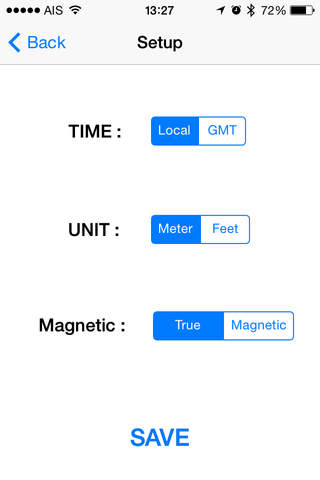
Main Features:
* Simple to use
* Quickly mark your location, two-axis inclinometer and compass
* Full map integration
* Multiple views (map, satellite, hybrid)
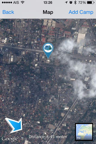
* Distance from camp tracked
* Compass to find your way back to your camp
That combines viewfinder, clinometer, compass, GPS and map.
Triangulation consists of making such direction plots of the surrounding landscape from two separate standpoints. The two graphing papers are superimposed, providing a scale model of the landscape, or rather the targets in it. The true scale can be obtained by measuring one distance both in the real terrain and in the graphical representation.
Main Features:
* Simple to use
* Quickly mark your location, two-axis inclinometer and compass
* Full map integration
* Multiple views (map, satellite, hybrid)
* Distance from camp tracked
* Compass to find your way back to your camp
Fotogalerie


-
Verze programu
1.6
-
Poslední aktualizace od vývojáře
10. 3. 2017
-
Počet stažení za měsíc
0 ×
-
Velikost
48,16 MB
-
Potřeba instalace:
Ano
-
Web autora
-
Systémové požadavky
Aplikace pro: iPhone, iPad
-
Podporované jazyky
- Angličtina
Cena: 0,99 €
Aplikace pro: iPhone, iPad
Sdílet
Podobné programy

TIP: Stahují se vám programy pomalu? Změřte si rychlost svého internetového připojení.