 Gulf of Mexico Tide Tables
3.0
Gulf of Mexico Tide Tables
3.0
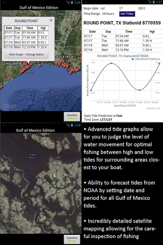
Easy to use tide charts displayed on a Satellite Map for the entire Gulf of Mexico region on a simple to use satellite map. Designed by fishermen and fishing guides.
NO SPAM ADS, SIMPLE TO USE...100% AD FREE.
This edition covers the following state's tide charts: Texas tides, Louisiana tides, Mississippi tides, Alabama tides, and Florida tides including the Gulf and East Coast tides of Florida.
Other Features:
Easy to Use, advanced tide graphs allow for you to judge the level of water movement for optimal fishing between high and low tide.
Ability to forecast tides from NOAA by setting date and period for any of the tidal stations for the entire Gulf of Mexico including: Texas, Louisiana, Mississippi, Alabama and Florida.
When GPS is available auto-locate your position and zoom to the map for surrounding NOAA tide stations.
Included is the ability to zoom and view satellite imagery for fishing ground characteristics to compare with tide movement.
Support URL: http://www.nestides.com/contact-us/
Privacy Policy & Terms of Use URL: http://www.progresstechnologies.com/blog/120/privacy-policy-and-terms-of-use/
Fotogalerie

-
Verze programu
3.0
-
Poslední aktualizace od vývojáře
10. 10. 2019
-
Počet stažení za měsíc
0 ×
-
Velikost
15,16 MB
-
Potřeba instalace:
Ano
-
Web autora
-
Systémové požadavky
Aplikace pro: iPhone, iPad
-
Podporované jazyky
- Angličtina
Cena: 249 Kč
Aplikace pro: iPhone, iPad
Sdílet
Podobné programy
TIP: Stahují se vám programy pomalu? Změřte si rychlost svého internetového připojení.